Kohechi Trail
Key information: Kohechi Trail 
- 4 day hike along ancient, World Heritage listed pilgrimage routes through the rugged forested mountains of Japan's Kii peninsula.
- Start at Koyasan, littered with esoteric Buddhist temples. Walk southward past old villages, shrines and other sites for some 70km to Hongu in the heart of the sacred Kumano area.
- Stay in very Japanese accommodation along the way. Enjoy the remote towns and villages of still remarkably undeveloped rural Japan.
- This is a tiring walk in a frequently wet area. Come prepared.
ANYONE GOT ANY GOOD PHOTOS? WE WOULD BE DELIGHTED TO POST THEM!
Walkopedia rating
- Walkopedia rating85
- Beauty30
- Natural interest13
- Human interest14
- Charisma30
- Negative points2
- Total rating85
- Note: Neg: likely bad weather
Vital Statistics
- Length: 70km
- 4 days
- Maximum Altitude: 1,719m
- Level of Difficulty: Strenuous
This walk description page is at an early stage of development, and will be expanded over time. Your comments on this walk, your experiences and tips, and your photos are very welcome.

WALK SUMMARY
This walk is the toughest of the various Kumano Kodo walks to Hongu, a 4 day hike along ancient, World Heritage listed pilgrimage routes through the rugged forested mountains of Japan's Kii peninsula.
Start a Koyasan, which is littered with esoteric Buddhist temples. Walk southward, generally against the grain of the land, past old villages, shrines and other sites for some 70km to Hongu in the heart of the sacred Kumano area.
Stay in very Japanese accommodation along the way. Enjoy the remote towns and villages of still remarkably undeveloped rural Japan.
Jane McBride comments: "Our four day walk from Koyasan through to Hongu Taisha was great. We had a night in a temple in Koyasan at the start and managed minshuku etc on way. After the walk we went to Yunomine Onsen to relax our tired legs, and then Katsuura and nearby whale town Toji."
Best Months: Spring and early Summer for flowers, including the famous cherry blossom, in mid Spring. June and July are rainy season. Summer is hot and humid. Bright mid-autumnal colours.
This is a tiring walk in a frequently wet area. Come prepared.

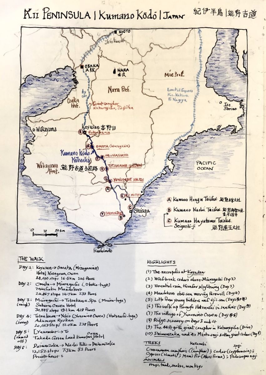
Thanks to Stephen Barber for the lovely map!
This page is at an early stage of development. Please help us by making suggestions and sending photos! Thank you!
For more information and photos, including detailed practical information and some warnings, see our Kumano Kodo walk page.
OUR FRIENDS' EXPERIENCES
Walking with Trees: the Kumano Kodo Kohech, October 2019
By Walkopedia friend Stephen Barber. Walkopedia says thank you, Stephen! Fascinating and brings back the extraordinary atmosphere of the region!
Anyone who loves trees, especially ancient trees, and walks the Kohechi will find themselves in arboreal heaven. From Osaka, we took a car for the two-hour journey south to Koyasan. Halfway, a short detour by the town of Katsuragicho took us to the tiny shrine of Jugosha, to meet the biggest living thing in Kansai—a 600-year-old monster camphor tree with a girth of 13.5m (44 feet).
Seasoned travellers in Japan expect exceptional amenities wherever they go. Some will have walked all, or part of, the celebrated pilgrimage routes through Wakayama and Nara prefectures known collectively as the Kumano Kodo—the Ohechi, the Nakahechi and the Kohechi.
Perversely, they may, like my wife Kimiko and I, choose to walk the Kohechi (the ‘small route’) in October—from the Buddhist monasteries of Mount Koya to the three great Kumano shrines. If so, in four days it’s a 70km walk south-east on one of the most remote, arduous and least frequented trails in Japan—and, except in the valleys, with hardly a single village or even public facility along the way.
But this makes the route, formally known as the Kumano Sankei-michi Kohechi, is a uniquely rewarding experience. This thousand-year-old pilgrimage way was mapped out and used by Buddhist monks from Koyasan right up to the middle years of the last century. Once well served by tea houses, long since abandoned, the Kohechi is dotted with their desolate remains, boarded up or even lost to the encroaching.....
READ MOREYour comments on this walk, your experiences and suggestions, and your photos are very welcome. Where appropriate, you will be credited for your contribution.

Safety and problems: All walks have inherent risks and potential problems, and many of the walks featured on this website involve significant risks, dangers and problems. Problems of any sort can arise on any walk. This website does not purport to identify any (or all) actual or potential risks, dangers and problems that may relate to any particular walk.
Any person who is considering undertaking this walk should do careful research and make their own assessment of the risks, dangers and possible problems involved. They should also go to “Important information” for further important information.

Anyone planning an expedition to this place should see further important information about this walk.
Responsible travel matters, a lot. How you travel will make a real difference - for better or worse. PLEASE consider this when making plans. Read more


